
Other Projects
Overview
With the addition of the Cable Bay Southwest (“CBSW”), Ox Lake, Brown Lake, and Harrison Projects the Company now has ownership interests in ten projects, totalling over 209,867 acres across the uranium-rich Athabasca Basin. With three earn-in option agreements completed since expanding the Company’s business strategy to include project generation in addition to pure exploration strategies, the Company continues to seek strategic partners to advance non-core projects, including these newly acquired assets.
Cable Bay SW Project
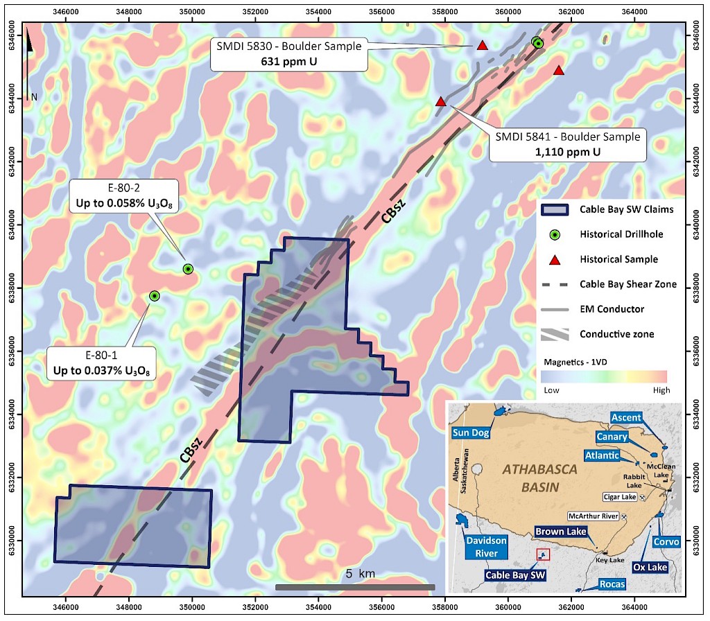
The CBSW project comprises two mineral claims totalling 3,158 ha and is approximately 18 km south of the present-day margin of the Athabasca Basin. The project covers 8.6 km of the northeast trending Cable Bay Shear Zone (“CBSZ”), a major structural discontinuity which is host to several uranium occurrences proximate to and along strike of the structural corridor on the property. The CBSZ is characterized by a regional magnetic high corridor flanked by magnetic gradients. Electromagnetic (“EM”) surveys conducted in the late 1970’s outline an EM zone associated with a magnetic low, paralleling the northwestern flank of the CBSZ. The northern claim block covers an apparent left-lateral break in the magnetic high corridor, with the eastern splay of magnetic high tying into the hinge of an interpreted fold structure of metasedimentary rock units on the property. The Project has never been drill-tested, and will benefit from additional surface sampling and geophysical surveys to aid in future drill target generation.
Ox Lake Project
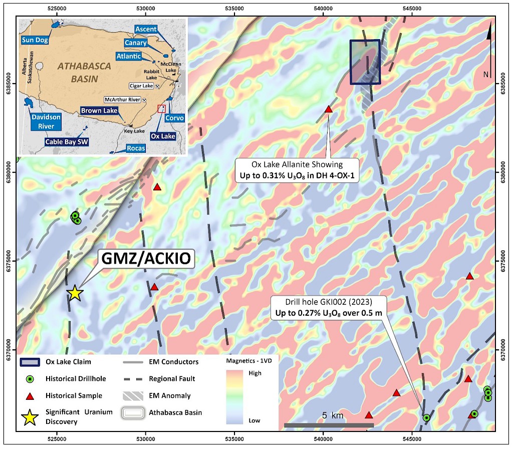
The Ox Lake Project consists of one mineral claim totaling 397.5 ha, situated 3 km southeast of the Athabasca Basin margin, 45 kilometres southeast of McArther River Mine, and 19.5 km northeast of the Gemini Mineralized Zone (“GMZ”) and the ACKIO uranium discovery. The project is highlighted by a regional northeast-trending magnetic low/EM corridor that is bisected by a north-south trending Tabbernor-style fault corridor, interpreted to be a regional structural influence on uranium mineralization in the area (Figure 2). Results from drill hole GKI002 completed by CanAlaska Uranium and Basin Energy on the neighbouring Geikie project in 2023 returned 0.27% U3O8 over 0.5m to the south along strike of the same interpreted Tabbernor fault that transects the Ox Lake property. Additionally, the Ox Lake Allanite Showing, discovered immediately southwest of the property, hosts up to 0.31% U3O8 in drill hole 4-OX-1. Historical geochemical surveys conducted on the project detected elevated uranium, radioactivity, and anomalous radon that are favorably situated proximal to the structural corridor on the property.
Brown Lake Project
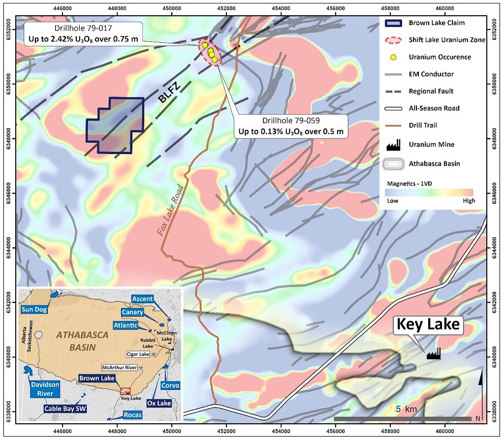
The Brown Lake Project consists of one mineral claim totalling 312 ha, situated near the southeastern margin of the Athabasca Basin, 13 kilometers northwest of the Key Lake Mill facilities. The property hosts 2.4 km of an untested magnetic low/fault trend that is 4 km southwest along strike of the Shift Lake Uranium Zone. The Shift Lake zone contains mineralized drill holes 79-17, 79-40, 79-45, and 79-59, in which uranium assays greater than 0.10% U3O8 were returned, notably 79-17 which hosts 0.62% U3O8 over 2.75 m and up to 2.42% U3O8 over 0.75 m. In 2011, 3D modelling of previous magnetics and resistivity depth imaging (“RDI”) slices delineated a northeast-trending fault zone, termed the Brown Lake Fault Zone (“BLFZ”; Figure 3). Recent modelling also defined an anomalous conductive body on the property based on alteration-related conductive halos observed in RDI sections, supporting the inferred continuation of the Shift Lake conductive trend and therefore prospectivity for uranium mineralization. The all-season highway between Key Lake and Points North is 12 km to the southeast of the property, while the Fox Lake fork off the main highway lies within 2 km of the eastern property boundary (Figure 3).
Harrison Project
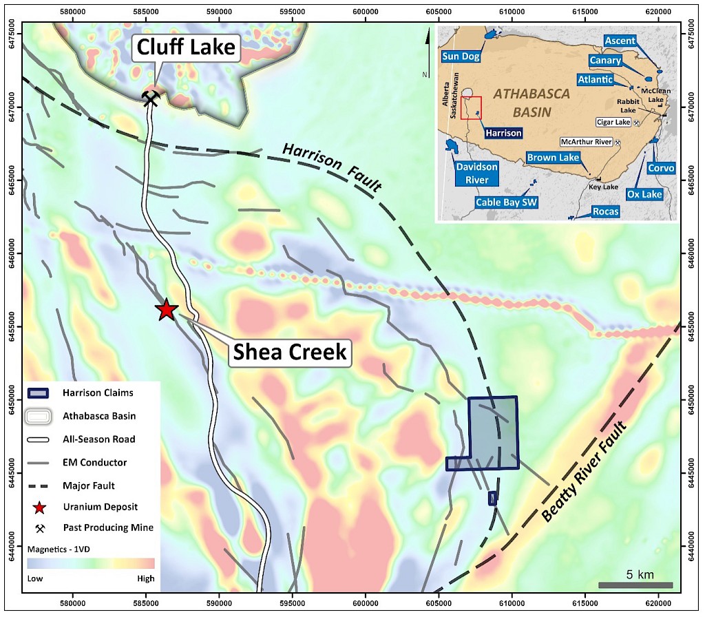
The Harrison project is comprised of two mineral claims totalling 1,750 ha, located 22 km SSE of the Shea Creek uranium deposits and approximately 30 km SE of the past producing Cluff Lake uranium mine. Electromagnetic (“EM”) surveys conducted in 2006-2007 outlined multiple EM zones across the property. The project covers approximately 6.8 km of a NW-SE conductor trends coincident with a magnetic low. The trend is crosscut by several interpreted fault zones, including 4.9 km of the major Harrison fault. The Project has never been drill-tested, and will benefit from additional surface sampling and geophysical surveys to aid in future drill target generation.
The Company believes the newly acquired Projects are prospective for the discovery of high-grade basement-hosted and unconformity-related uranium mineralization and are open to option deals on these non-core projects. The staking of these Projects fits with the Company’s strategy to increase its landholdings in the infrastructure-rich eastern Athabasca Basin of Saskatchewan, Canada.
Disclosure of Technical and Scientific Information
Except as otherwise noted herein, Sean Hillacre, MSc. P.Geo., Standard Uranium’s VP Exploration, has reviewed and approved the scientific and technical information contained in this website. Mr. Hillacre is a Qualified Person within the meaning of Canadian Securities Administrator’s National Instrument 43-101.