Umbra Project
The Umbra project comprises two mineral claims totaling 3,679 hectares, located 19 km WNW of the McArthur River Mine (Figure 1). The project area is 4 kilometres (“km”) NW along trend from West McArthur mineralized drill holes WMA-010 and WMA-004 which host up to 0.29% U3O8 (SMDI# 3553, 3551). On the eastern claim, Umbra covers the confluence of a strong electromagnetic (“EM”) conductor and interpreted graphitic/pelitic basement lithologies derived from the 2006 FALCON magnetic/gravity surveys, as well crosscutting E-W regional faulting. Additionally, resistivity depth slices derived from the 2007 audio-frequency magnetotellurgics (“AMT”) survey identified a low resistivity hotspot which corresponds to a distinct flexure in the EM conductor on the eastern claim. The western claim hosts NE-trending magnetic lows coinciding with regional faulting – indicative of additional undefined conductive trends that warrant further geophysical investigation.
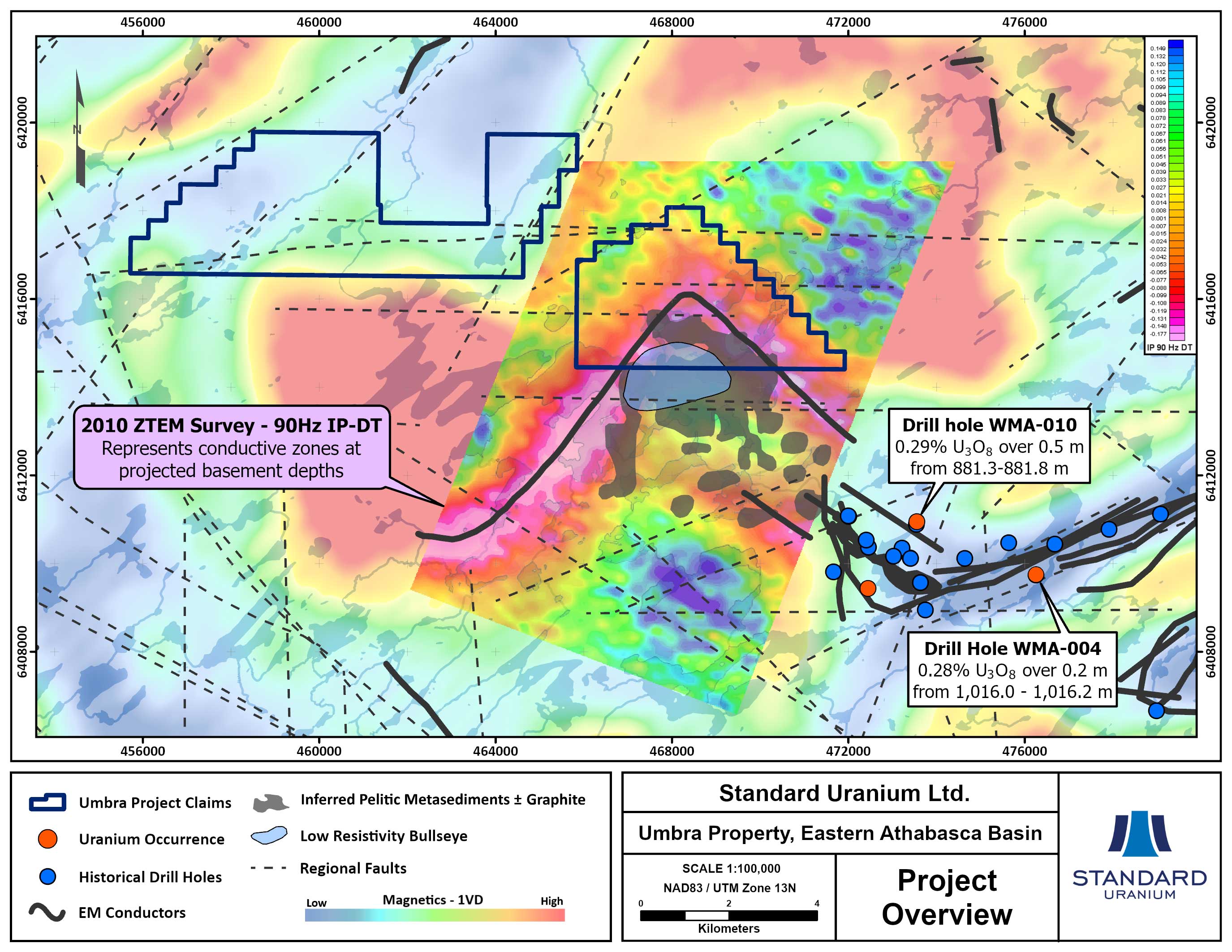
Figure 1. Map highlighting magnetic low/EM conductor trends on the Umbra project with first vertical derivative magnetics in the background
Harrison Project
The Harrison project is comprised of two mineral claims totaling 1,750 hectares, located 22 km SSE of the Shea Creek uranium deposits and approximately 30 km SE of the past producing Cluff Lake uranium mine (Figure 2). Electromagnetic (“EM”) surveys conducted in 2006-2007 outlined multiple EM zones across the property. The project covers approximately 6.8 km of a NW-SE conductor trends coincident with a magnetic low. The trend is crosscut by several interpreted fault zones, including 4.9 km of the major Harrison fault. The Project has never been drill-tested and will benefit from additional surface sampling and geophysical surveys to aid in future drill target generation.
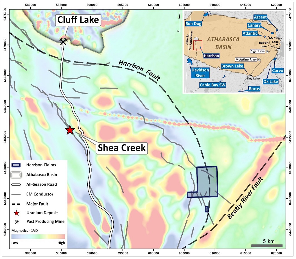
Figure 2. Map highlighting the magnetic low/EM conductor trends on the Harrison project with first vertical derivative magnetics in the background.
Cable Bay SW
The Cable Bay SW project comprises two mineral claims totaling 3,158 hectares and is approximately 18 km south of the present-day margin of the Athabasca Basin (Figure 3). The project covers 8.6 km of the northeast trending Cable Bay Shear Zone (“CBSZ”), a major structural discontinuity which is host to several uranium occurrences proximate to and along strike of the structural corridor on the property. The CBSZ is characterized by a regional magnetic high corridor flanked by magnetic gradients. Electromagnetic (“EM”) surveys conducted in the late 1970’s outline an EM zone associated with a magnetic low, paralleling the northwestern flank of the CBSZ. The northern claim block covers an apparent left-lateral break in the magnetic high corridor, with the eastern splay of magnetic high tying into the hinge of an interpreted fold structure of metasedimentary rock units on the property. The Project has never been drill-tested and will benefit from additional surface sampling and geophysical surveys to aid in future drill target generation.
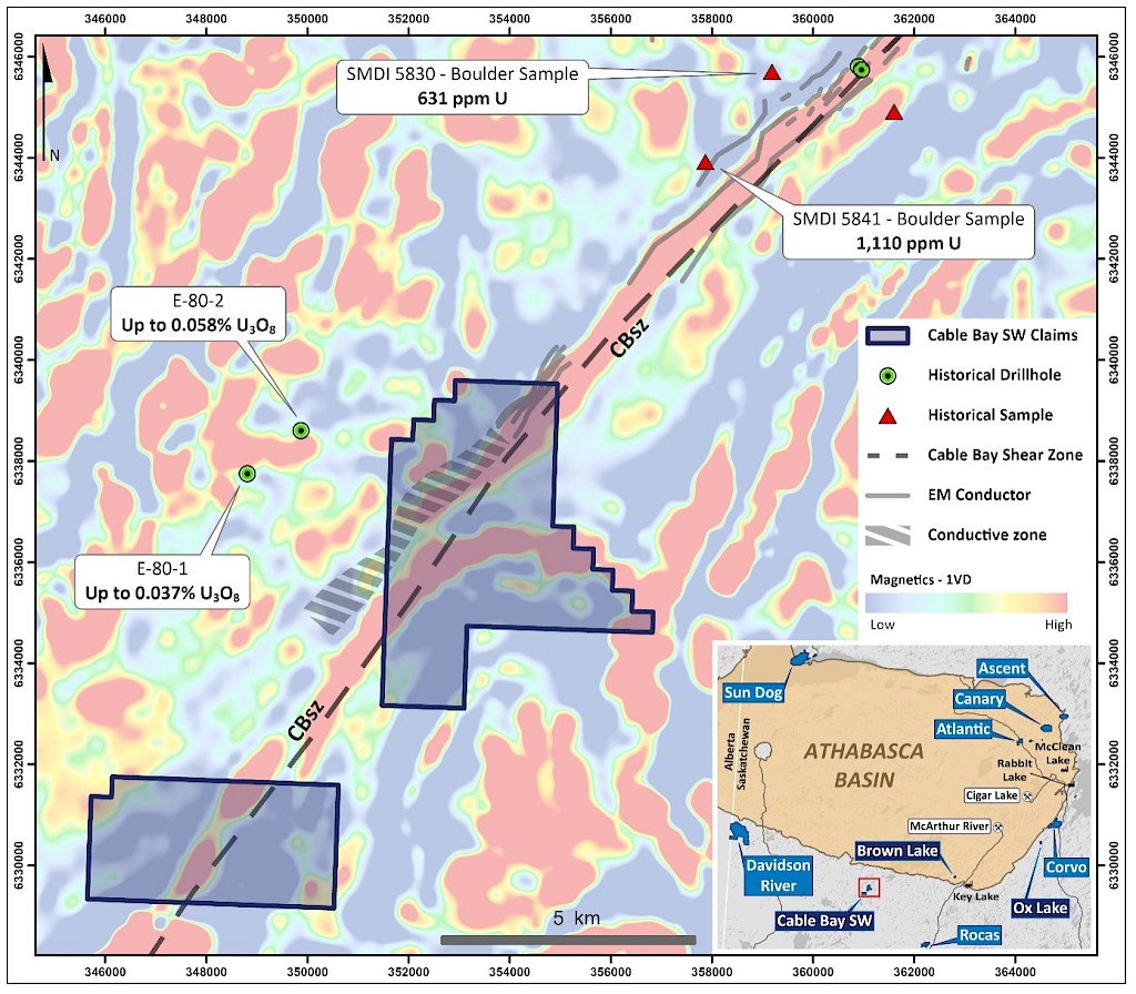
Figure 3. Map highlighting the Cable Bay shear zone and EM conductor trends on the Cable Bay SW project along strike from anomalous uranium samples, with first vertical derivative magnetics in the background.
Sable
The Sable project is comprised of three mineral claims totaling 4,008 hectares, located 35 km NW of the Cigar Lake uranium mine and approximately 42 km SW of the Hurricane uranium deposit (Figure 4). Sable covers two NE-SW trending magnetic lows and one NW-SE trending low, interpreted to represent prospective metasediments within folded granitic rocks (Figure 4). The inferred conductors extend over a strike length of more than 4 km and remain untested by drilling. The completion of a new, modern airborne EM geophysical survey would upgrade the Project.
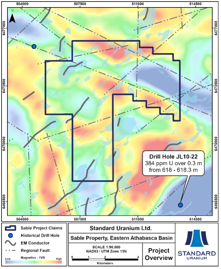
Figure 4. Map highlighting magnetic low/EM conductor trends on the Sable project with first vertical derivative magnetics in the background.
